Scientists from NASA and other agencies are using satellites to map damage caused by the devastating earthquake in the Republic of Türkiye. On February 6, 2023, two earthquakes of magnitudes 7.8 and 7.5 hit southern Turkey and western Syria, resulting in widespread devastation across both nations
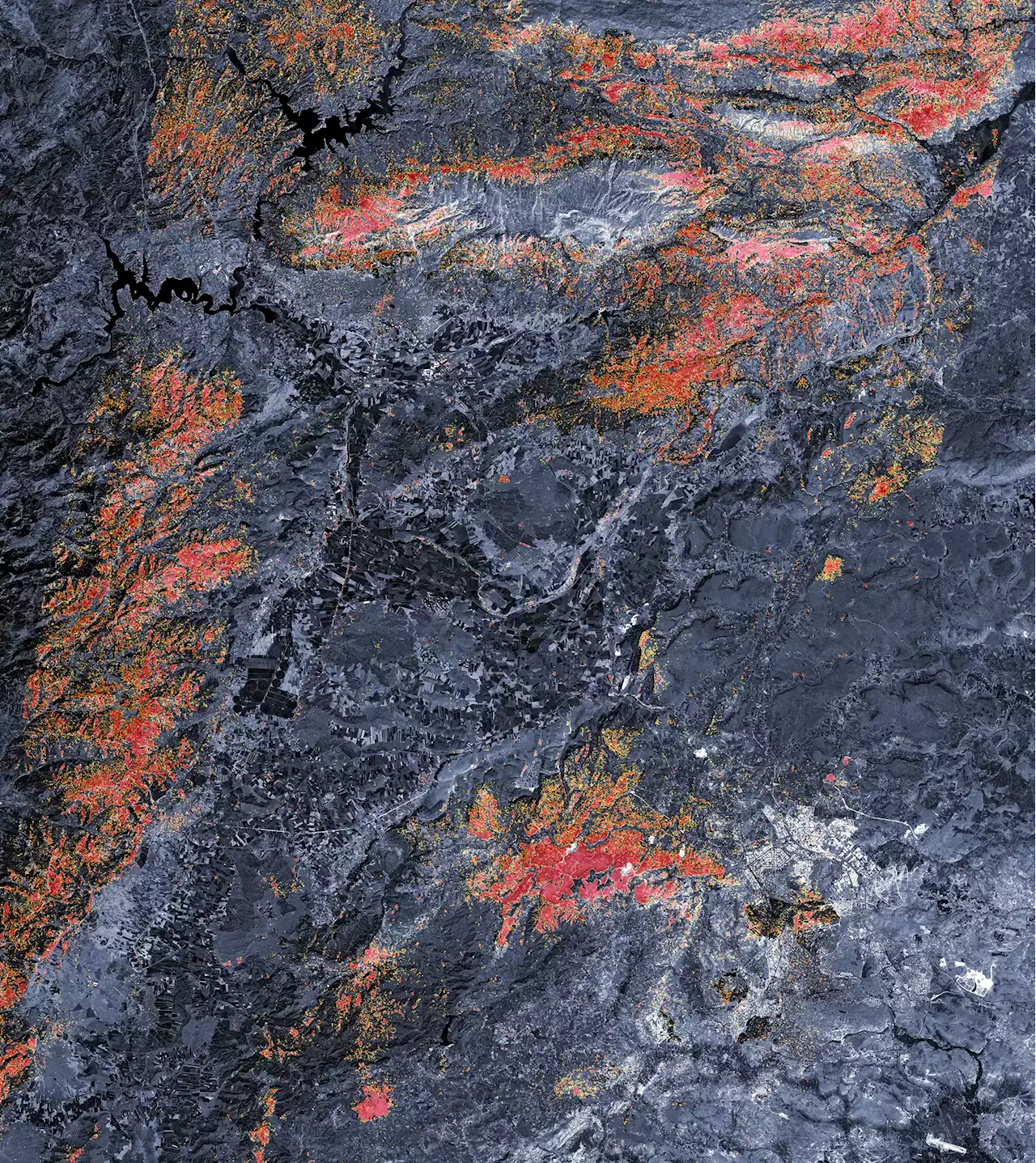
Map derived from data collected by PALSAR-2 on the Advanced Land Observing Satellite-2 on February 8, 2023.
On February 6, 2023, two earthquakes of magnitudes 7.8 and 7.5 hit southern Turkey and western Syria, resulting in widespread devastation across both nations.originated from a fault line located 18 kilometers beneath the surface, which resulted in violent shaking that impacted a wide radius from the epicenter. The first quake was followed by another powerful 7.5 magnitude earthquake nine hours later, as well as hundreds of smaller aftershocks.
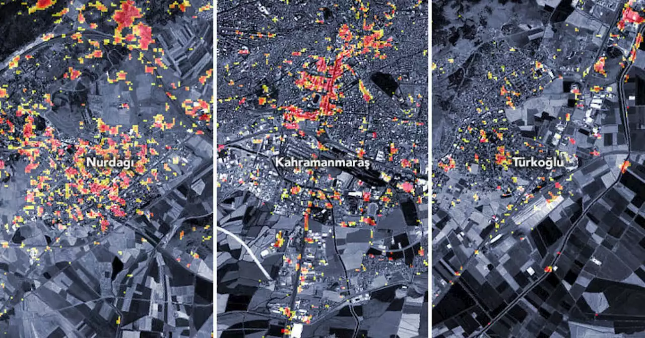
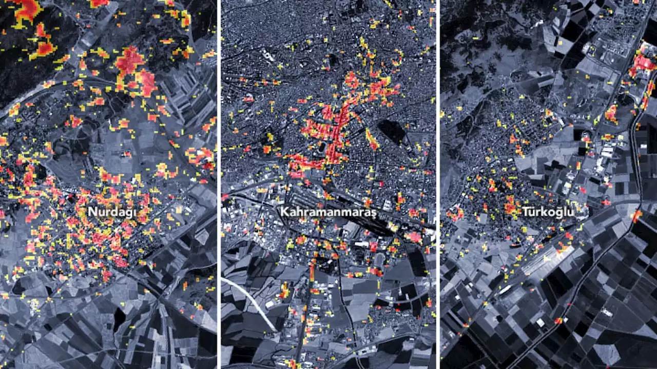
“These were very large and powerful earthquakes that ruptured all the way up to the surface over a long series of fault segments,” said Eric Fielding, a geophysicist at The preliminary damage proxy map above shows parts of the cities of Türkoğlu, Kahramanmaraş, and Nurdaği. Dark red pixels represent areas likely to have severe damage to buildings, homes, and infrastructure or changes to the landscape, while orange and yellow areas are moderately or partially damaged. Each pixel measures about 30 meters across .
France Dernières Nouvelles, France Actualités
Similar News:Vous pouvez également lire des articles d'actualité similaires à celui-ci que nous avons collectés auprès d'autres sources d'information.
 Satellites could power Turkey-Syria earthquake rescue efforts and aidBetter humanitarian aid delivery is made possible by quickly directing satellite eyes toward affected areas.
Lire la suite »
 Satellite images show Turkey-Syria quakes 'similar to the 1906 earthquake that destroyed San Francisco,' NASA saysSatellite images from the NASA Earth Observatory show the scale of destruction in Turkey and Syria.
Lire la suite »
 Turkey earthquake live updates: Death toll rises 23,000 in Turkey, SyriaDramatic satellite imagery from 2020 and then after the devastating 7.8 magnitude Turkey-Syria earthquake shows the land rupture, breaking the earth in the Turkish city of Nurdagi in Gaziantep province.
Lire la suite »
 Turkey earthquake live updates: Death toll passes 28,000 in Turkey, SyriaMore than 28,000 people are dead in Turkey and Syria as a result of last week's earthquake and aftershocks, officials say.
Lire la suite »
 'Disaster of the century': NASA maps extent of Turkey-Syria earthquake devastationTwo earthquakes with magnitudes 7.8 and 7.5 devastated southern Turkey and western Syria on February 6, 2023. Now NASA is using satellites to map the extent of the devastation to aid relief efforts.
Lire la suite »
![]() Hurricane-tracking satellites can also keep tabs on harmful microplastics in the oceanSmaller waves form on watters laden with microplastics.
Hurricane-tracking satellites can also keep tabs on harmful microplastics in the oceanSmaller waves form on watters laden with microplastics.
Lire la suite »