“Everywhere you look on Earth, you see something new.” ScienceMagArchives
East Africa has been called the cradle of humanity. But the geologically active region has also given birth to dozens of volcanoes. Few have been monitored for warnings of a potential eruption, and until recently, most were believed to be dormant. Then, Juliet Biggs decided to take a closer look—or rather, a farther look.
And the flood of InSAR data is growing fast. Since 2018, the number of civil and commercial SAR satellites in orbit has more than doubled. And at least a dozen more are set to launch this year, which would bring the total to more than 60. With the help of computing advances that make data processing easier, the satellite fleets may soon be able to detect daily or even hourly surface changes at just about every patch of ground on Earth.
Many believe InSAR will eventually underpin our daily lives. From measuring the water stored in mountain snowpacks to enabling quick responses to natural disasters, InSAR data will prove invaluable to governments and industries, says Cathleen Jones, a science team leader for NISAR, an upcoming joint SAR mission from NASA and the Indian Space Research Organisation ."I want it to become so socially relevant that they can't go back to not having this data.
Glaciologists adopted the technology, too. As a young researcher at JPL in the 1990s, Ian Joughin used InSAR—which tracks both vertical and horizontal movements—to measure the speed of polar ice streams. Some scientists thought flow rates would be relatively immune to climate change. But, sadly for the world, InSAR studies by Joughin and others proved those predictions wrong.
Norway's national deformation map, based on InSAR data from Sentinel-1 satellites, showed parts of Oslo's train station sinking by more than 1 centimeter per year, perhaps because of nearby construction. Rouet-Leduc and his team now plan to monitor faults around the world using the same approach. He says it's mostly a matter of exploiting the vast quantity of data that"sits on servers without being looked at," because it's simply too much for scientists to tackle. The researchers hope they will be able to answer questions like when and why slow earthquakes happen, and whether they can trigger big, damaging events by increasing stress on other parts of a fault.
France Dernières Nouvelles, France Actualités
Similar News:Vous pouvez également lire des articles d'actualité similaires à celui-ci que nous avons collectés auprès d'autres sources d'information.
 Earth’s true core is a 400-mile-wide iron ball, according to a new studyA new study suggests that Earth's true core could be a ball of iron-nickel that scientists hadn't uncovered yet.
Lire la suite »
 Earthquakes reveal odd 'fluid' rock layer in Earth's solid mantleA new study demonstrated the potential existance of a fluid rock layer at the very bottom of the upper mantle, that may be ring the entire planet.
Lire la suite »
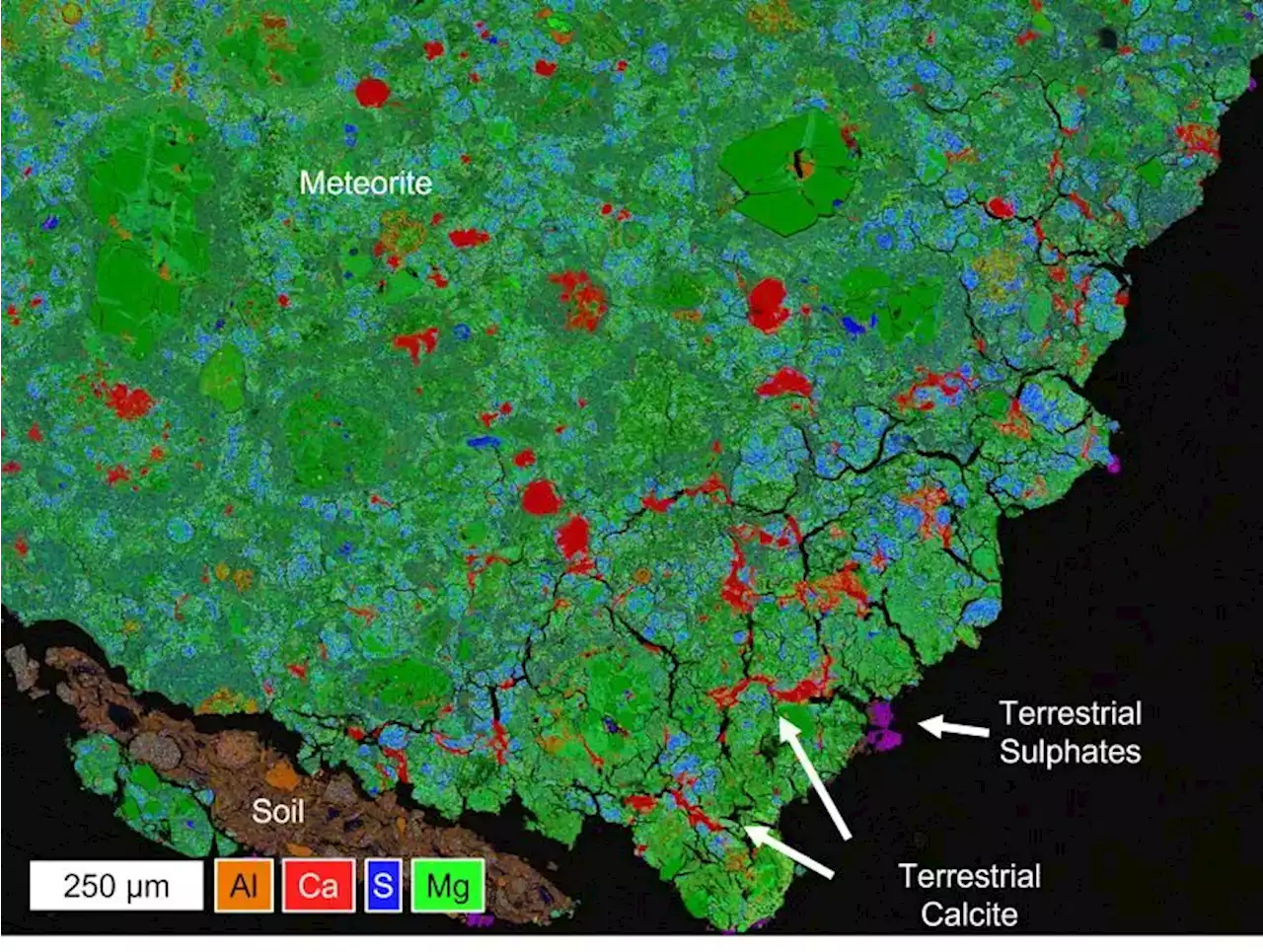 Meteorites are Contaminated Quickly When They Reach EarthOn Earth, geologists study rocks to help better understand the history of our planet. In contrast, planetary geologists study meteorites to help better understand the history of our solar system. While these space rocks put on quite the spectacle when they enter our atmosphere at high speeds, they also offer insights into both the formation … Continue reading 'Meteorites are Contaminated Quickly When They Reach Earth'
Lire la suite »
 Conquering Space Weather – Study Successfully Overcomes Earth’s Gravity To Replicate Planetary ConditionsA study conducted at UCLA successfully overcomes the influence of Earth's gravity, replicating conditions found on other planets and stars. Solar flares and various forms of space weather can cause significant disruptions in spaceflight and satellite-based telecommunications. However, scientists' e
Lire la suite »
 Deep Earthquakes Reveal Shocking Secrets of the Inner Earth350-mile-deep earthquake used in scientific study to make elusive measurements of the Earth’s layers. There may be a layer of surprisingly fluid rock ringing the Earth, at the very bottom of the upper mantle, according to a new study from a University of Chicago scientist. The finding was made
Lire la suite »
 NASA Satellite Shoots Wall of Green Lasers Down to EarthHawaii's Big Island was treated to a light show of space lasers — but luckily, it wasn't aliens that put on the stunning spectacle.
Lire la suite »