
Thursday is going to be another warm one across much of the Province. Highs will be into 20s for many areas. The highest readings will be found over portions of Central and eastern Newfoundland, where a HEAT WARNING continues today. Locations in the warning can expect highs in the upper 20s, with humidex values into […]
The showers and thunderstorms we are seeing this evening across a large portion of central and western areas will ease later this evening and overnight. The showers and storms will move northeast and offshore and should be mostly done by midnight. Eastern areas will by dry and eventually mostly clear, and areas of fog may linger for southern shorelines. Lows around 17° across the Island.
Friday will see a mostly dry day across the Island, with perhaps a few morning showers on the Avalon. Highs will be in the mid to upper 20s again. The weather pattern changes a bit Saturday as the jet stream shifts a mean trough over the region. This will bring cooler temperatures and a more active weather pattern for the weekend and next week.Rain will be found on the north coast and around Upper Lake Melville overnight.
Thursday will see a dry start for most, except on the north coast, where rain will be found. Scattered showers and thunderstorms will develop in the west and drift to the east throughout the day. Highs range from the mid-teens in the north and west to the lower 20s for Goose Bay and Norman Bay to Lodge Bay area.
The weekend and next week look to remain active over the Big Land, with chances for rain in the forecast and temperatures remaining cool. At this point, there doesn’t look to be any major weather in play.
France Dernières Nouvelles, France Actualités
Similar News:Vous pouvez également lire des articles d'actualité similaires à celui-ci que nous avons collectés auprès d'autres sources d'information.
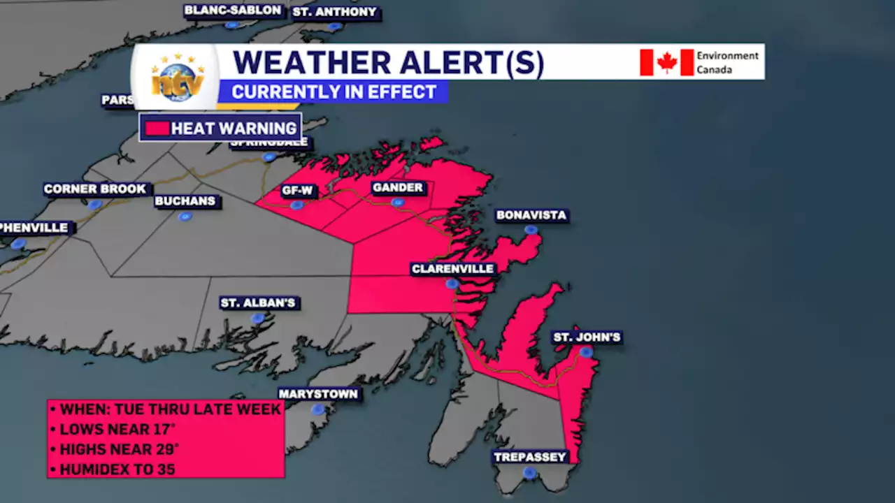 Heat Warning in effect for parts of eastern and Central Newfoundland thru ThursdayThe ECCC NL Weather Office in Gander has issued a HEAT WARNING for the following areas: Here is the alert text from ECCC NL Current details:A period of very warm and humid weather is expected. Time span: continuing until Thursday. Maximum daytime temperatures: near 29 degrees Celsius (Humidex near 34).Minimum nighttime temperatures: near 17 degrees […]
Lire la suite »
 Toronto and much of southern Ontario under heat warningA heat warning is now in effect for the Greater Toronto Area and much of southern Ontario, with scorching temperatures in the forecast and humidex values expected to reach as high as 40 in the coming days.
Lire la suite »
 Heat warning in Toronto, southern Ontario ahead of it feeling like 40 degreesA heat warning is now in effect for the Greater Toronto Area and much of southern Ontario, with scorching temperatures in the forecast and humidex values expected to reach as high as 40 in the coming days.
Lire la suite »
 GTA under heat warning, southern Ontario braces for ‘extremely hot’ days: Environment CanadaA sweltering heat wave is forecasted for the remainder of the week, posing a health risk and further deteriorating air quality.
Lire la suite »
 Toronto under heat warning as Ontario braces for ‘extremely hot’ weather this weekA sweltering heat wave is forecasted for the remainder of the week, posing a health risk and deteriorating air quality for much of Ontario, including Toronto.
Lire la suite »
 Heat warning forecasts 30C across southwestern Ontario, no relief until SaturdayThe latest stretch of hot and humid weather comes after a multi-day heat wave earlier this month contributed to the hottest week globally on record
Lire la suite »